सरकारी अधिकृत पत्रे, टेप मोजमाप, ULPIN अनुपस्थिती, संशयास्पद मोजणी — सर्व पुरावे एकत्र. प्रत्येक दावा कागदावर आधारित. Official government letters, tape measurements, missing ULPIN, suspicious survey — all evidence compiled. Every claim backed by documents.
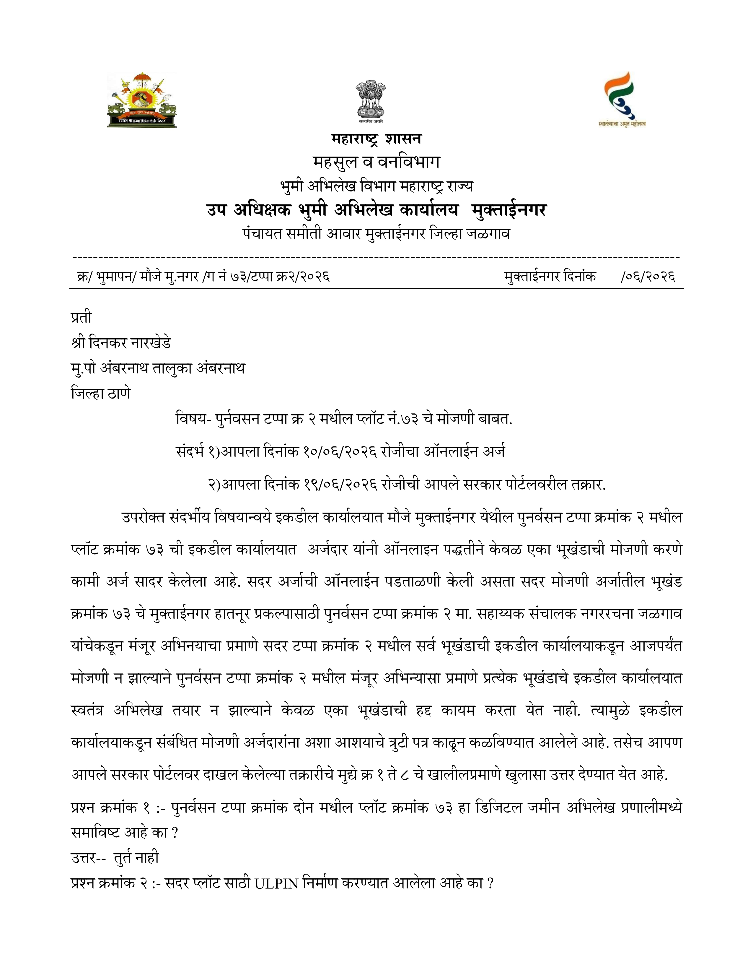
उप अधीक्षक भूमी अभिलेख कार्यालय, मुक्ताईनगर यांनी दिनकर रामभाऊ नारखेडे यांच्या ऑनलाइन अर्ज (दि. १०/०६/२०२६) व आपले सरकार तक्रार (दि. १९/०६/२०२६) यांना उत्तर देताना अधिकृत पत्रात खालील महत्त्वाच्या गोष्टी मान्य केल्या —
The Deputy Superintendent Land Records Office, Muktainagar, in response to Dinkar Rambhau Narkhede's online application (10/06/2026) and Aaple Sarkar complaint (19/06/2026), officially admitted the following in writing —
DySLR मुक्ताईनगर स्वतः अधिकृतपणे मान्य करतं की पुनर्वसन टप्पा २ मध्ये कोणत्याही भूखंडाची हद्द अधिकृतपणे निश्चित झालेली नाही. कोणत्याही अधिकृत मोजणीशिवाय शेजारील भूखंडधारकांनी स्वतःच्या सोयीने जागा घेतली.
DySLR Muktainagar itself officially admits that in Punarvasan Tappa 2, no plot boundary has ever been officially fixed. Without any official survey, neighbouring plot holders occupied land as per their convenience..
* वरील मोजमाप हे अंदाजे टेपद्वारे केलेले प्राथमिक निरीक्षण असून ते कोणत्याही अधिकृत भू-मापनाचा पर्याय नाही. अधिकृत मोजणीची मागणीच आमची मुख्य मागणी आहे.
* Above measurements are approximate tape-based observations and not a substitute for official land survey. An official survey is precisely what we are demanding.
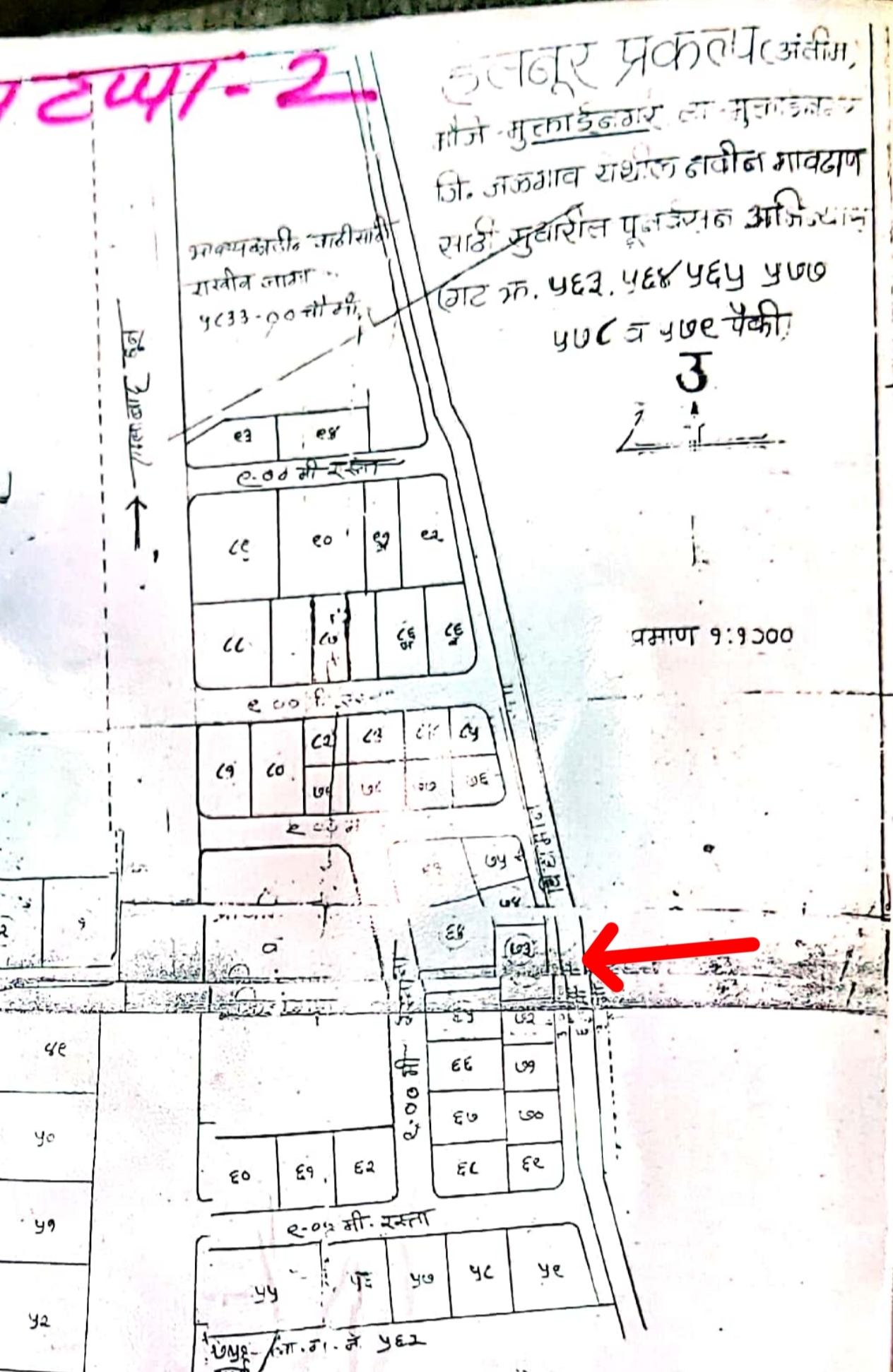
ULPIN (Unique Land Parcel Identification Number) ही प्रत्येक जमीन तुकड्याची डिजिटल ओळख आहे. पुनर्वसन टप्पा २ मधील पुनर्वसन टप्पा २, प्लॉट क्र. ६९, ७०, ७१, ७२, ७४, ७५ — या सर्वांना ULPIN प्रदान करण्यात आले आहे. एकट्या पुनर्वसन टप्पा २, प्लॉट क्र. ७३ ला — म्हणजे माझ्या जमिनीला — ULPIN नाही.
ULPIN (Unique Land Parcel Identification Number) is the digital identity of every land parcel. Punarvasan Tappa 2, Plot No. 69, 70, 71, 72, 74, 75 — all have been assigned ULPIN. Only Punarvasan Tappa 2, Plot No. 73 — my land — has no ULPIN.
DySLR मुक्ताईनगर यांनी RTI अर्ज क्र. RA&FD/R/2026/62491 च्या उत्तरात ULPIN नसण्याचे कारण स्पष्ट केले नाही. RTI तपशील पाहा →
DySLR Muktainagar did not provide a clear reason for the missing ULPIN in response to RTI application No. RA&FD/R/2026/62491. View RTI details →
पुनर्वसन टप्पा २, प्लॉट क्र. ७४ साठी दि. २७/११/२०२० रोजी मो.र.क्र. ७४५ अंतर्गत मोजणी करण्यात आली. या मोजणीत अनेक गंभीर अभिलेखीय त्रुटी आहेत ज्या आम्ही तक्रारींद्वारे अधोरेखित केल्या आहेत.
A survey was conducted under M.R. No. 745 on 27/11/2020 for Punarvasan Tappa 2, Plot No. 74. This survey contains several serious documentary irregularities which we have highlighted through complaints.
या मोजणीबाबतचा संपूर्ण तपशील, कागदपत्रे व औपचारिक मागणी येथे पहा: मोजणी क्र. ७४५ — संपूर्ण विश्लेषण वाचा →
Read the full breakdown, documents, and formal demand for this survey: Mojni No. 745 — Read the Full Breakdown →
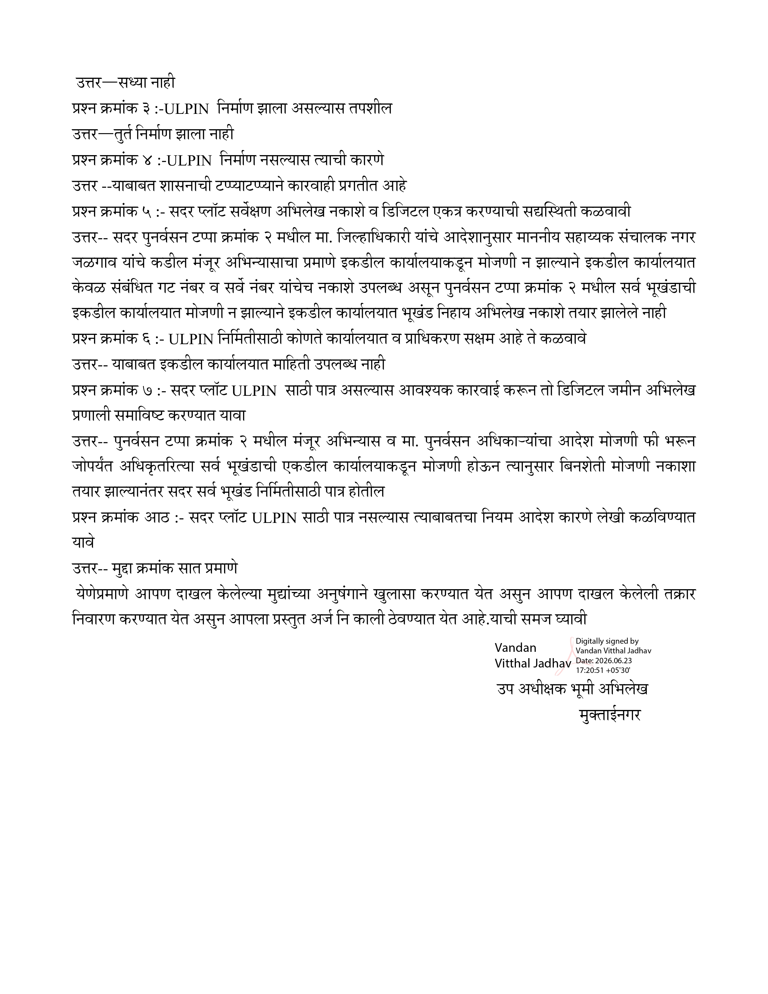
उप अधीक्षक भूमी अभिलेख कार्यालय, मुक्ताईनगर यांनी Grievance Token DIS/REVD/JALG/2026/123 च्या उत्तरात, दि. ११/०७/२०२६ रोजीच्या पत्रात, मुद्दा क्रमांक ६ मध्ये स्वतः लेखी नमूद केले आहे —
The Deputy Superintendent Land Records Office, Muktainagar, in its reply to Grievance Token DIS/REVD/JALG/2026/123 dated 11/07/2026, stated in writing under Point No. 6 —
सरकार स्वतः लेखी कबूल करते की पुनर्वसन टप्पा २ मधील भूखंड क्र. ७४ ची — किंवा या अभिन्यासातील कोणत्याही भूखंडाची — हद्द अद्याप अधिकृतपणे निश्चित/कायम झालेलीच नाही. मग प्रश्न असा आहे — जमिनीवर प्रत्यक्षात जे हद्दीचे दगड रोवले गेले आणि कंपाऊंड बांधण्यात आले, ज्यामुळे माझ्या पुनर्वसन टप्पा २, प्लॉट क्र. ७३ ला अपेक्षित जागेपेक्षा कमी जागा शिल्लक राहिली — ते कोणी, कोणत्या अधिकृत मोजणी किंवा आदेशाच्या आधारे उभारले? कोणतीही हद्दच निश्चित नसताना दगड व कंपाऊंड जमिनीवर कसे आले, याची स्वतंत्र चौकशी होणे आवश्यक आहे.
The government itself admits in writing that the boundary of Plot No. 74 — or indeed any plot in this layout — has never been officially fixed. This raises the obvious question — who physically installed the boundary stones and built the compound wall on the ground — the ones that have left my Punarvasan Tappa 2, Plot No. 73 with less area than it should have — and under what official survey or order? If no boundary was ever fixed, an independent inquiry is needed into how these boundary markers and the compound came to exist on site at all.
त्याच दिवशी (११/०७/२०२६) दाखल झालेल्या दुसऱ्या तक्रारीच्या (Grievance Token DIS/REVD/JALG/2026/4) उत्तरात, DySLR मुक्ताईनगर यांनी पाच स्वतंत्र मुद्द्यांद्वारे पुढील बाबी लेखी मान्य केल्या आहेत —
In its reply to a separate complaint (Grievance Token DIS/REVD/JALG/2026/4) filed the same day (11/07/2026), DySLR Muktainagar admitted the following in writing across five points —
DySLR मुक्ताईनगर स्वतः अधिकृतपणे मान्य करतं की पुनर्वसन टप्पा २ मध्ये कोणत्याही भूखंडाची हद्द अधिकृतपणे निश्चित झालेली नाही. कोणत्याही अधिकृत मोजणीशिवाय शेजारील भूखंडधारकांनी स्वतःच्या सोयीने जागा घेतली.
DySLR Muktainagar itself officially admits that in Punarvasan Tappa 2, no plot boundary has ever been officially fixed. Without any official survey, neighbouring plot holders occupied land as per their convenience.
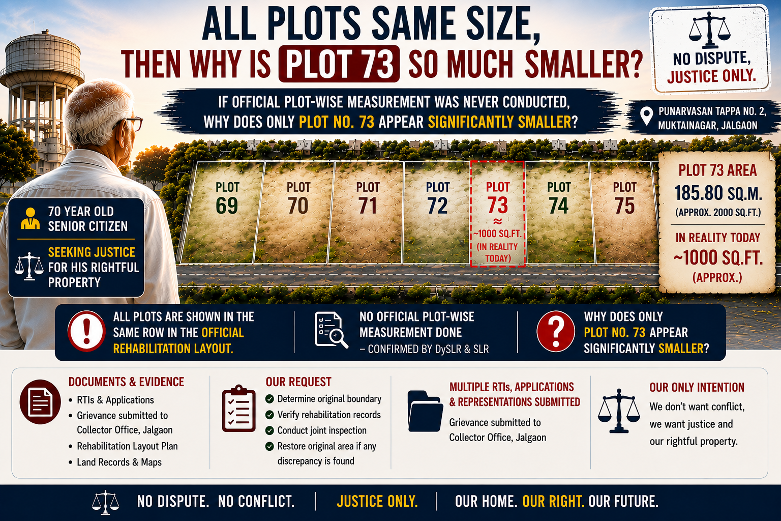
ज्याने जितकी जागा अडवली — तितकी त्याची झाली. जो दूर राहिला — त्याची जमीन कमी झाली. पुनर्वसन टप्पा २, प्लॉट क्र. ७३ ला २००० चौरसफूट ऐवजी फक्त ~१००० चौरसफूट उपलब्ध आहे. हे अतिक्रमण नाही का?
Whoever occupied more — kept it. Whoever stayed away — their land shrank. Punarvasan Tappa 2, Plot No. 73 has only ~1000 Sq.ft instead of 2000 Sq.ft. Is this not encroachment?
एकमेव उपाय: पुनर्वसन टप्पा २, प्लॉट क्र. ६९ ते ७५ ची अधिकृत एकत्र मोजणी.
The only solution: Official collective survey of Punarvasan Tappa 2, Plot No. 69 to 75.